Services | Webmail | Links | Film Shopping | Dining Earthquakes | Planets | Fire | Weather | Moon | Sun Satellite | Volcano | Holidays | Roads

 THE 'JAVA-TRONIC'
GREEN CAFE
HOURS
Please, appointments only, until further notice.
Our email is info@greencafe.com and our phone
is (951) 659-6000.
Notice: As of May 5, 2026, Green Cafe is twenty-nine years old. Yes, we have been happily in Idyllwild the whole time.
SERVICES
We are an Internet service provider, located at an elevation above
5,500 feet. Our services include WEBSITE DESIGN, EMAIL, FIBER, CABLE INTERNET, WIRELESS and COMPUTER ASSISTANCE.
We are Idyllwild based and provide some specialized computer and Internet
related services. Additionally, if you came up "The Hill" for the weekend and
somehow forgot something technically important, we might be able to tell you where in town,
or near town, where you can get the item.
Our primary focus is the advancement and preservation of the arts,
culture and the environment through the use of digital technologies. We
strongly believe that Idyllwild is much more than a collection of
pleasant shops ... but in fact a collection of creative talent
located in a dramatic environment that rivals any other area on
earth.
AROUND THE SHOP
What type of person hangs around the Green Cafe? Have a seat, hold your breath and look at some of society's greatest public enemies...
---
LINKS SECTION
As so much has rapidly changed on the Idyllwild scene, we thought we
would completely revamp our links section. Below, a new listing for 2026 is being
initiated and we anticipate you will soon find that each entry embraces a substantially
Idyllwild centric and integrated nature.
...
MAJOR HOLIDAYS
Major holidays are presented below and represent a combination of federal,
state and commonly observed breaks in routine.
THE 'JAVA-TRONIC'
GREEN CAFE
HOURS
Please, appointments only, until further notice.
Our email is info@greencafe.com and our phone
is (951) 659-6000.
Notice: As of May 5, 2026, Green Cafe is twenty-nine years old. Yes, we have been happily in Idyllwild the whole time.
SERVICES
We are an Internet service provider, located at an elevation above
5,500 feet. Our services include WEBSITE DESIGN, EMAIL, FIBER, CABLE INTERNET, WIRELESS and COMPUTER ASSISTANCE.
We are Idyllwild based and provide some specialized computer and Internet
related services. Additionally, if you came up "The Hill" for the weekend and
somehow forgot something technically important, we might be able to tell you where in town,
or near town, where you can get the item.
Our primary focus is the advancement and preservation of the arts,
culture and the environment through the use of digital technologies. We
strongly believe that Idyllwild is much more than a collection of
pleasant shops ... but in fact a collection of creative talent
located in a dramatic environment that rivals any other area on
earth.
AROUND THE SHOP
What type of person hangs around the Green Cafe? Have a seat, hold your breath and look at some of society's greatest public enemies...
---
LINKS SECTION
As so much has rapidly changed on the Idyllwild scene, we thought we
would completely revamp our links section. Below, a new listing for 2026 is being
initiated and we anticipate you will soon find that each entry embraces a substantially
Idyllwild centric and integrated nature.
...
MAJOR HOLIDAYS
Major holidays are presented below and represent a combination of federal,
state and commonly observed breaks in routine.
|
INFO
NEWS & SERVER UPDATES
The Idyllwild temperature is 58 °F. Wind speeds are mild and gusts are up to 5 mph. The humidity is at 49% while the pressure has held steady to 1012 mb. The skies are entirely clear with a 0% cloud_base. Visibility is five to six miles.
Updated: 07/09/2026 @ 12:00 a.m.
This second week in July, 2026, We will be focusing on upgrading our spam prevention system. Please call (951) 659-6000 or email us at info@greencafe.com should you have any questions. --- SUNRISE SUNSET IN IDYLLWILD Sat Jun 13 2026 Astronomical Dawn 03:48 am Nautical Dawn 04:29 am Civil Dawn 05:05 am Sunrise 05:34 am Sun Transit 12:45 pm Sunset 07:57 pm Civil Dusk 08:26 pm Nautical Dusk 09:02 pm Astronomical Dusk 09:43 pm Daylight: 14 Hours 22 Min Civil Light: 15 Hours 21 Min --- MOONRISE MOONSET IN IDYLLWILD Thu, Jul 9, 2026 Moonrise 12:58 am Waning Crescent Moonrise 01:37 am (07/10) Waning Crescent Moonset 03:15 pm Waning Crescent Moonset 04:28 pm (07/10) Waning Crescent New 06/14 @ 07:56 pm 1st 06/21 @ 02:56 pm Full 06/29 @ 04:58 pm 3rd 07/07 @ 12:31 pm New 07/14 @ 02:45 am 1st 07/21 @ 04:06 am Full 07/29 @ 07:37 am 3rd 08/05 @ 07:23 pm --- WEATHER FORECASTS Below forecasts provided by the National Weather Service (NWS). The reported wind direction has been removed. The forecast is based geographically on North Circle Drive. ... (190/365) 07/9/26 Thu Overnight - Clear, with a low around 73° F. Calm wind becoming around 5 mph. Thursday - Sunny, with a high near 89° F. Wind 5 to 10 mph becoming calm in the morning. Winds could gust as high as 20 mph. Thursday Night - Clear, with a low around 71° F. Wind 5 to 10 mph. Friday Day - Sunny, with a high near 87° F. Wind 5 to 10 mph. Updated: Thu Jul 09 2026 @ 1:02 AM
--- Satellite imagery is an indispensable tool for determining weather conditions. Below is a recent satellite depiction of the Western United States and the Pacific Ocean, albeit with state boundaries superimposed. The satellite image is updated every five minutes. If the land mass is brown or the circle is green, then its daytime. Blue means the imagery is from nighttime. In case you are curious, the green circle is centered on Idyllwild, California and the red dot approximates the hand of a clock at the time of image capture. A yellow circle indicates nighttime. Current Satellite View: AIR MASS GOES satellite view will return. Yellow circles are not in effect in Air Mass view. 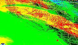
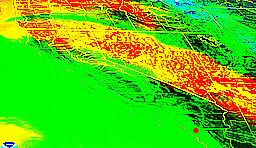
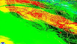
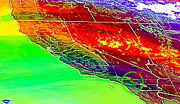
*** To view an animation ***
There are three animated satellite sequences to choose from: 1 Hr, 4 Hr and 16 Hr. When clicked, the image below the tab is a snapshot of the cloud conditions from that many hours ago. For example, if you selected the 4 Hr tab at 5 PM, then the image shown below portrays the action at 1:00 PM.
To view the animation from that time to current, simply move your mouse pointer near the green or yellow circle below. Wait a few seconds for the animation to start all the while keeping the mouse pointer near the green circle. The last image will pause for about seven seconds and represents the latest view before the loop starts again. * All satellite weather data provided by the National Oceanic and Atmospheric Administration (NOAA.gov). --- |
||||||||||||||||||||||||||||||||||||||||||||||||||||||||||||||||||||||||||||||||||||||||||||||||||||||||||||||||||||||||||||||||
If you have any questions, please contact us at info@greencafe.com. Copyright Green Cafe 1997-2026. All Rights Reserved. Weather data provided by NWS, NOAA, RAWS, CWOP, OpenWeatherMap,
personal & local monitoring stations. Area maps provided by Google Maps and OpenStreetMaps. Green Cafe makes no claims, promises or guarantees about the accuracy
of any information provided on this website.